H11 Handheld GNSS Receiver

The H11 is a 104g portable handheld GNSS receiver for personnel and vehicle positioning management, field survey, patrol, security and engineering reconnaissance, with four-constellation multi-frequency positioning, NTRIP corrections and real-time 4G reporting.
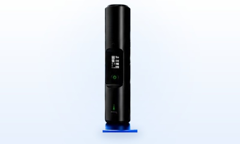
H11 black pen-style handheld GNSS positioning receiver
Lightweight professional handheld design: a compact, ergonomic non-slip body suited to long field sessions in surveying, inspection and sampling.
01 / OVERVIEW

Product Overview

A portable multi-frequency positioning terminal for personnel and vehicle positioning management, field survey and patrol. It supports BDS / GPS / GLONASS / GALILEO multi-frequency positioning with NTRIP differential input and real-time data return, an OLED display with key operation, and an IP67-rated body suited to body-worn and portable field use.

02 / SPECIFICATIONS

Core Specifications

ItemDetails
CategoryHandheld GNSS positioning receiver
PositioningBDS / GPS / GLONASS / GALILEO, multi-frequency
Update rateUp to 5 / 10 / 20 Hz
Communication4G data transfer + MQTT + NTRIP + dual-mode Bluetooth (classic + BLE)
Display & UIOLED display + key operation for device and positioning status
Protection & powerIP67; USB Type-C 5V/2A; battery and runtime details in the datasheet
03 / DEPLOYMENT

Typical Deployment & Use

Typical Deployment

  • Phone add-on module
  • Body-worn
  • Vehicle roof
  • Pole mount

Typical Use

  • Personnel and vehicle positioning management
  • Field survey
  • Patrol
  • Security and engineering reconnaissance
05 / SELECTION

H11 vs H13: choose by accuracy and carrying method

The H11 and H13 belong to the same YUEETEK handheld GNSS family, but they differ in positioning capability and body specifications. The H11 takes the lightweight route: a 104g body, 3300mAh battery, four-constellation multi-frequency positioning and NTRIP corrections, aimed at personnel and vehicle tracking, field survey and patrol. The H13 targets centimetre-level RTK fixes and survey stakeout, with a 4000mAh battery and a 140.5g body.

ItemH11H13
PositioningBDS / GPS / GLONASS / GALILEO multi-frequency; NTRIP correction inputBDS-3 full constellation / GPS / GLONASS / GALILEO / QZSS; centimetre-level RTK fixed solution
DifferentialNTRIPRTCM2.3, RTCM3.x, CMR
Battery / weight3300mAh / 104g4000mAh / 140.5g
DisplayOLED display with key operation28 x 13.5mm ISP high-definition display
Best forPersonnel and vehicle positioning, field survey, patrol, security and engineering reconnaissanceSurvey stakeout, pole survey, GIS collection and mobile work requiring centimetre-level RTK

For lightweight body-worn use, vehicle-roof mounting or phone add-on deployment, the H11's 104g body and 3300mAh battery are the better fit. If the job requires a centimetre-level RTK fixed solution, survey stakeout or faster RTK initialisation, go straight to the H13 handheld RTK terminal. Compare the item-by-item differences in Handheld RTK selection: H13 vs H11, review the Product Selection Guide, or contact us for project configuration.

Four checks before choosing the H11

  • Accuracy requirement: decide between NTRIP corrections with position reporting and a centimetre-level RTK fixed solution; choose the H13 for the latter.
  • Mounting method: phone add-on, body-worn, vehicle roof or survey pole, each with different power and antenna placement.
  • Data link: confirm 4G coverage, NTRIP/CORS credentials and the platform protocol (MQTT, JSON or JT/T808).
  • Protection and runtime: the body is IP67 and the battery is 3300mAh; confirm runtime against the datasheet and work frequency.
Product FAQ

H11 Functions & Applications FAQ

What applications is the H11 designed for?
The H11 supports personnel and vehicle tracking, field surveys, inspections, security and engineering surveys. It can be used with a phone, worn on the body, mounted on a vehicle roof or installed on a survey pole.
Which satellite systems does the H11 support?
The H11 supports BeiDou, GPS, GLONASS and GALILEO multi-frequency positioning and can receive NTRIP correction data.
What communication and interaction options does the H11 provide?
The H11 supports 4G transmission, MQTT, NTRIP, Bluetooth Classic and Bluetooth Low Energy. Device status and positioning information are available through the OLED display and keypad controls.
What are the H11 environmental and power specifications?
The H11 has an IP67-rated enclosure and uses USB Type-C 5V/2A power. Battery capacity and operating time are provided in the latest datasheet.
How are H11 price and availability confirmed?
The price value 0 is an inquiry marker; the actual price depends on configuration and order quantity. Standard models can be supplied according to project arrangements, and firm availability and delivery timing are confirmed after model and configuration review.
What is the difference between the H11 and H13?
The main differences are positioning capability and carrying specifications. The H11 supports BDS, GPS, GLONASS and GALILEO multi-frequency positioning with NTRIP corrections, weighs 104g and has a 3300mAh battery. The H13 supports five constellations and a centimetre-level RTK fixed solution, weighs 140.5g and has a 4000mAh battery. Choose the H11 for lightweight body-worn use, personnel and vehicle tracking and field patrol; choose the H13 for survey stakeout and centimetre-level RTK work.
Does the H11 provide an RTK fixed solution?
The H11 supports NTRIP correction input and real-time 4G reporting. If you need a centimetre-level RTK fixed solution, RTK initialisation and survey stakeout, choose the H13 handheld RTK terminal.
What are the H11 weight and battery capacity?
The H11 weighs 104g and has a 3300mAh battery. Actual operating time depends on work frequency, network use and display use; refer to the latest datasheet.